


Seismic Response to Lithology and Fluid

We can map variations in lithology and fluid content of a reservoir from an
interpretation of seismic data, as illustrated by the case histories in this
review. Successful mapping needs a simple relationship between variations in
lithology and the observable geophysical parameters; namely velocity, Poisson's ratio and AAI. Figure 4 shows the variation in these three parameters for stated changes in porosity, shale content and fluid fill for a North Sea reservoir.
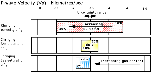
Changes in P-wave velocity for a typical sandstone (20% brine
filled porosity and 20% shale content)
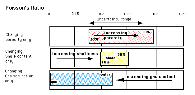
Changes in Poisson's Ratio for a typical sandstone (20% brine
filled porosity and 20% shale content)
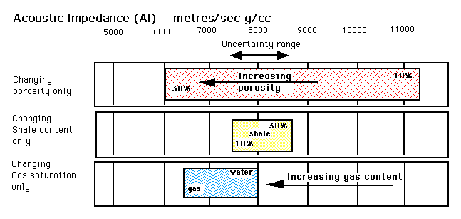
Changes in acoustic impedance for a typical sandstone (20% brine filled porosity and 20% shale content)
Figure 4 : Variation in P-wave velocity, Poisson's Ratio and
Absolute Acoustic Impedance for changes in porosity, shaliness and gas saturation of a typical sandstone.
Two problems can frustrate efforts to map lithology and fluid variations:
- No observable effects are caused by the lithology variations to be
mapped.
- Several changes in lithology occur at the same time, the changes in
one parameter masking the effects caused by another.
These are illustrated by a the two case histories below.
Case 1: A company tried to map the shaliness of a reservoir interval
using AAI estimation. The procedure for estimating AAI was established before discovering that AAI could not distinguish the sands and shales in the reservoir. This illustrates that we must establish the relationship
between the lithology and the geophysical parameters before embarking on any
sophisticated analysis.
Factors which can cause changes in the observable geophysical parameters,
include:
- Porosity
- Lithology
- Depth
- Compaction
- Mineralogy
- Fluid fill
- Fracture dimensions
Case 2: An attempt is being made to map the oil water contact in a reservoir using seismic data. This is particularly difficult because of the lateral changes in the porosity and depth of the reservoir. The relationship between lithology or fluid changes and geophysical parameters is non-unique in such situations. A reliable result can only be achieved if a geological model exists to constrain the possible solutions.


